Driving


Style ran a complaint letter today from a west ender who made her request known for improving Shockoe Bottom [emphasis mine]:

What I and all of my group want is not anything different than what is already being offered, it is improvement on what is being offered, with the main component being parking and free parking. Everyone in the West End I talk to wonders why no one gets it.

One of the main features that separates cities from suburbs is density. Stores, offices & housing are located close together, creating a visually interesting landscape. And more importantly, density makes it possible to walk from one shop to another, or from your house to your office. Density also makes transit economically feasible.

Parking lots tear holes in the urban fabric, make it harder to walk from one place to another, create stormwater runoff, contribute to the urban heat island effect, and are generally unpleasant to look at.

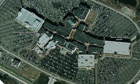
Shockoe Bottom is not a strip mall. It’s not a mall at all. It’s part of the urban fabric, and as such, driving from the suburbs and parking for free should not be its main goal. Shockoe shouldn’t look like this:

hell.gif

Downtown is already saturated with parking lots.

Everyone I talk to who lives in the city wonders why suburbanites don’t get it. If you want “parking and free parking,” don’t come downtown- go to the suburbs. There’s plenty of bars and clubs there.

There are already entire city blocks in the Bottom dedicated to nothing but parking. Don’t further destroy our city to cater to those addicted to their cars.

Unfortunately, according to Style, some of our urban businesses are struggling financially so much that they want to create suburbia in the midst of downtown:

…some merchants are working on solutions to the parking dilemma because this is the complaint they hear most often, from Carytown to Church Hill… As they fight off the suburban franchise mentality, many realize that those vast, treeless shopping mall parking lots are often what separates red and black on the bottom line.

The New York Times recently ran an editorial outlining how Paris, France has aimed to cut car traffic within the city by 40% by 2020. Here’s some of their tactics, some of which should be considered by Richmond in our effort to re-create our downtown:

  • Improve transit:
    • Increase and improve routes
    • Make transit cheaper
    • Make transit easier to use
      • public posting of bus routes
      • electronic signs at bus stops with the wait times for the next bus
      • make payment easier
  • Reduce available travel lanes for cars
  • Create special bus lanes (in Paris and London these lanes can be used by taxis & bikes)
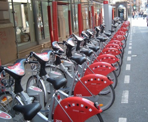
  • Make cheap rental bikes available all over the city ($1.50 a day or $43.50 a year)
  • Raise fuel taxes

Maybe instead of 2-way streets downtown, we should keep them 1-way and dedicate one lane for buses and bikes. That would calm traffic, provide access for emergency vehicles, and make transit faster and biking safer.

And I’d love to see inexpensive rental bikes all over the city- I don’t know the specifics of the Paris system, but in Amsterdam you can pay your rental fee and get a key which works for a generic lock on all the bikes. Then you can pick up a bike anywhere you find one, and leave it at approved destinations. This kind of program works only with a very high volume of bikes (Paris is starting with 10,000 at 750 locations and hopes to double the number of bikes by the end of the year). It also requires housing density to ensure that bikes are available where people live.

In Lyon, your pre-paid bus/metro card will unlock rental bikes. How’s that for convenient?

The point is, when you declare war on cars there has to be viable, affordable, convenient alternatives for folks to get around.  If we want to make downtown less of a traffic paradise and more pedestrian oriented, what transportation alternatives are we providing?  Otherwise we risk running everyone out of downtown and killing it off entirely, don’t we?

paris bikes

The TD ran a story today on Chinese students who are spending a month at VCU. The students are all keeping blogs, which are a rich mine for discovering others’ impressions of our city.

VCU has links to all their blogs, but as far as I can tell, there’s no aggregator- which means you have to look through each of them individually. Quite a task as there’s over 50 of them. I used google’s advanced search features to look for things of interest for my blog.

One theme I found repeated by many was shock at our auto-dependency and its effect on our city- a viewpoint I wholeheartedly share. Here’s some excerpts:

America is regarded as a country on wheels. This is a proper statement to describe this country . I have seen various kinds of automobiles parking of driving around the campus during these two days. And there is little people walking on the street even in the day . The whole town appears a little desolate. This is my first deep impression about the traffic condition around VCU campus. My second deep impression is that though there are various cars on road, the drivers almost do not ring the horn—at least I do not hear a ring. It is impossible in China. Maybe this phenomenon is just the symbol of high civilization of USA. And in my opinion , Chinese drivers should learn from America drivers.
Via blog for luy5

Sadly, the VCU area probably has the most pedestrian activity in town.

On our lack of pedestrians and nightlife:

if Shanghai is a sleepless city,Richmond is a sleep city

Richmond in night looks like a different city. full of cars but no person on the street. Its strange to me becoz its totally different from Shanghai. Shanghai is a sleepless city, the activities of night are varous, compare with Shanghai, Richmond is a quiet city, I heard that the population of Richmond is 80 thousand, its not a small figure, so i wondering, where do the risidents go at night in Richmond?? Stay at home, watching TV?
Via blog for zhuangy

Wow, the population figure’s off by about 110,000 and he’s still shocked at our lack of nightlife!

An incredibly insightful commentary on our auto-dependency:

However, not all the things American are good. There are still something I find impressively unbearable. For example, I find the Americans are lavish. They do not know how to save. They do not know how to save the resources and natural energy. Instead, they are pretty good at saving the energy of themselves. Along the American streets, you can never find a single bicycle. Even if you see a bicycle, it is definitely put on the top of the car. People are inclined to drive everywhere. They do not walk or ride. I think it is part of the reason that why most of them are overweight.
Via blog for liz4

And she’s not the only one making the obesity-driving connection:

It’s our free day today. I decided to go to the Carytown again. I have no car and I don’t want to bother those interns. Thus, I have to walk there, on foot! To my surprise, Carytown’s out of the map, maybe ten blocks away for the GRC [Gladding Residence Center- A VCU dorm]. You can seldom see people walking on the street. Almost all of them drive. Finally I got to the Carytown and I found it was not very far. It’s only about 30 minutes walk. I suddenly thought up with a cause why Americans are fat. Perhaps because they drive too much, sit too long. On one hand, they complain about the soaring gas price, on the other hand, they are so dependent to driving. Instead, if they walk to some places. They will both get jogging exercises and save the gas money. It’s really a bargain!
Blog for Zhang Yi

Try telling some Richmonders “it’s only a 30 minute walk” and see what happens!

Despite the critiques of American culture I’ve highlighted here to advance my own purposes- without exception the Chinese students have positively glowing things to say about Richmond and the US.

On what’s good about Richmond:

At the same time, the wonderful scenery of Richmond is really overwhelming.I love the small bars and restaurants along the fancy streets. I was attracted by the rockiness and wildness of James River. And I was deeply in love with the monuments for the soldiers and sailors who died in the civil war. The most terrific part was the visit to the Virginia Capitol. The house was marvelous and the historic presidents’ stories could not be more significant.
Via blog for liz4

And then there’s the just plain fun of discovering cultural differences, such as impressions of our T-shirt slogans:

Yesterday afternoon we went to Carey Town, which was a place full of shops and stores. Maybe because that China has lots of such shops, I didn’t find it much interesting and attractive. I wanted to buy a T-shirt for my cousin, which were very typical American, but I didn’t find any suitable for him. Some of them seemed too aggresive or radical, maybe. For example, one had a line like “I love your girlfriend” sort of things. If my cousin wears something like that and walks on the road in China, everybody else will probably freak out.
Via blog for wuj4

Thanks to all the Chinese students for visiting our city and sharing your impressions with us!


The recent design charrette has provided a little controversy for our city and for engaged bloggers. Should downtown convert its street grid from one-way to two-way streets? Divergent views are already emerging.

Explaining and defending the charrette’s recommendation of a two-way street conversion downtown is Buttermilk & Molasses. John’s post “THE DOWNTOWN PLAN: ONE-WAY OR ANOTHER” ably presents the controversy and advocates for the conversion.

Representing concern over this proposed change is the Richmond Business & Commercial News blog in the post “Ending One-Way Streets in Richmond?” A local traffic engineer, Bear, joins the debate in the comments section with data and sound logic advocating for the status-quo.

The controversy has also made its way to Richmond City Watch’s forum, an on-line forum for all things Richmond, with a focus on architecture & urban planning.
Check out Bear’s posts here (covering similar ground) and the many responses in the forum’s Downtown Charrette discussion.

I’ve spent the afternoon researching the claims each side is making and trying to determine if there is a clear case to be made for either side. Most arguments on both sides of the local debate center on making downtown a safer and more inviting environment for non-motorists, a goal almost universally shared.

My view: there is no obvious choice here.

The smoking gun for my ambivalence is the Federal Highway Administration’s Pedestrian Safety Report on “One-Way/Two-Way Street Conversions,” which concludes that compelling reasons exist for both types of streets from a pedestrian safety perspective.

Reasons for converting to 2-way streets:

  • Slower traffic speeds.
  • Decrease “Vehicle Miles Traveled” by eliminating indirect routes (driving around the block to get to your destination).
  • Increased access to businesses.
  • Possibly: safer for pedestrians.

Reasons for maintaining 1-way streets:

  • Conversion is very costly.
  • 1- way streets allow for more cars, thereby decreasing congestion.
  • Easier than 2-way streets to time stoplights (timed lights improve traffic flow and decrease idling (& therefore pollution)).
  • Fewer turn prohibitions.
  • More on-street parking.
  • Possibly: safer for pedestrians.

A note of clarification: turns are often prohibited on heavily traveled 2-way streets to maintain traffic flow (think Hull St. in Manchester, or Boulevard during rush hour). On-street parking is sometimes lost as the extra lane used for parking is reclaimed for travel purposes. And both sides in this debate argue that their choice is the safest for pedestrians.

Unfortunately, most of the information I found about the pros and cons of converting streets was written by highly partisan organizations which were promoting ideological arguments for or against automobile-oriented development. These studies were less academic in nature and more akin to propaganda. I searched academic databases, government sites, and google. At any rate, here’s a rundown of studies I found helpful.

One of the better studies was published by the Transportation Research Board, “Downtown Streets: Are We Strangling Ourselves on One-Way Networks?” which advocates for 2-way streets. “This paper provides a comparison of one-way versus two-way street systems for downtowns and presents an evaluation methodology for considering two-way conversion.”

The study discusses Bear’s comment on the Business & Commercial News blog that “One-way streets eliminate conflict points” and argues the opposite. The heart of the issue is, in my own blunt rewording, from how many directions can pedestrians be hit? Bear and others argue that 1-way streets provide fewer “conflict points,” while the Transportation Research Board argues that 1-way street networks provide many more possible types of street intersections. Examples include a 1-way street intersecting with another 1-way street, a 1-way street intersecting with a 2-way street, and a 1-way street which becomes 2-way at an intersection (think Main & Cary sts. where they convert to 2-way). 1-way street networks increase the variety and kind of conflict points creating more confusion for pedestrians and motorists.

The highly technical article “A MICROSCOPIC SIMULATION STUDY OF TWO-WAY STREET NETWORK VERSUS ONE-WAY STREET NETWORK” argues that, “one of the inherent disadvantages with one-way street is that they force additional turning movements at the intersections caused by motorists who must travel “out-of-direction” to reach their destination. The additional turning movements for a one-way street network increase the occurrences of vehicular-pedestrian conflicts at any given intersection, and also result in a system-wide increase in vehicle mile of travel (VMT) as compared to a two-way street network.”

In other words, you have to turn more on a 1-way street network, and therefore have more chances of running over people.

I found both of these sources on Streetsblog.org, a NYC-focused blog with a helpful article arguing against converting streets to one-way in Brooklyn.

On the other side of the debate is the Center for the American Dream of Mobility and Homeownership’s paper “No Two Ways About It: One-Way Streets are better than Two-Way.” The most convincing evidence produced in this paper is that pedestrians were hit more frequently after streets were converted to 2-way in several downtowns in the US. I’d prefer to cite those studies directly rather than this obviously partisan article, but I could not track them down on-line. The references in this article contain a lot of garbage (highly ideological publications, newspapers, and studies more than 50 years old), but the empirical evidence cited about the number of accidents resulting from recent 2-way conversions is convincing.

I am personally biased towards 2-way streets. They put less emphasis on moving as many cars as possible, they slow traffic, and provide a more inviting atmosphere for pedestrians. However, I’m not sure that compelling enough evidence exists for their benefits in a downtown region to justify the expense required to do a full-scale conversion.

What I’d like to see is more empirical evidence for the claims of both sides, focusing on the many regions which have recently switched their downtown street networks. Denver, Raleigh, and Cambridge, MA, among many others, have recently done this. What’s their experience been? Has downtown experienced a resurgence? Have their been fewer or more pedestrian accidents?

The issue of pedestrian accidents is a salient one for Richmond. We have the dubious distinction of placing 2nd in large Metro areas with worsening pedestrian safety (Orlando’s number 1).

Richmond-Petersburg, VA MSA in 1994-95 scored a 41.4 on the “pedestrian danger index” and a 70.5 in 2002-03.

The danger index is a measure of the average yearly pedestrian fatalities per capita, adjusted for the number of walkers. In other words, a lot more people are getting run over by cars.

Of course, I doubt many of those accidents occurred downtown, likely they’re in Midlothian and Short Pump. But it seems like a discussion of improving pedestrian safety, downtown and around the rest of the metro area, is timely.
VDOT and the Virginia Capital Trail Foundation are building a 55 mile bike & pedestrian trail linking Williamsburg, Jamestown, and Richmond – the current and former capitals of Virginia.

Parts of the trail are already open in James City County: see photos here.

Current discussions are ongoing regarding the exact route and location of the trail in the Varina area of Henrico Co. This is where things get depressing.

First, there’s the timing. According to the planners, the trail won’t open until 2012. And we all know how accurate construction projections are, so it very possibly could take even longer. Call me impatient, but I was hoping for a quicker completion.

Second, there’s Henrico Co. government who seem to be trying their best to design this project to suit their car-dependant needs. Today’s TD outlines the desire of Henrico Board of Supervisors Chairman James B. Donati Jr.:

…he hopes to influence the trail’s design.

He believes the trail should be built as an extended shoulder of Route 5, instead of a swath of pavement separated by grass and landscaping.

He contends a wide shoulder would make Route 5 safer, because it would accommodate cyclists and slow-moving farm equipment, plus give room for delivery trucks to stop without impeding traffic on the 55-mph road.

Now contrast this with the stated purpose of the trail, as outlined by the Virginia Capital Trail Foundation- which is collecting private money to supplement inadequate government funds for this project:

The Trail is designed for non-motorized use and welcomes hikers, cyclists, walkers, joggers, skaters, birders, families taking short day trips and chaperoned school children on eco-field trips.

The Trail will provide safe recreational access to the region and link popular tourism destinations. It will offer cyclists a safe transportation alternative to Route 5…

So somehow in the twisted world of Donati and possibly others in Henrico gov’t, the trail should be open to use by “slow-moving farm equipment” and parked delivery trucks- which is completely incompatible not only with the trail’s purpose, but also with bicycle and pedestrian safety, and presumably the premise under which funds for the trail were secured.

And it’s galling that he argues that this would make a “safer” Route 5. Safer for whom? The only people who benefit from Donati’s vision are those in cars- not those who’re using the Capital Trail.

Can you see groups of school children on eco-field trips dodging tractors and walking around UPS vans while 55 mph+ SUVs and tractor trailers zoom by only inches away? Brilliant idea!

And of course, the newspaper, who we assume was present when Donati made these comments, did not bother to question him on the contradiction between his vision and the trail’s purpose (or if they did, they neglected to report it.) Because, really, who in Richmond doesn’t want to make the world safer for cars, even if it’s at the expense of pedestrians, cyclists, and little school children?

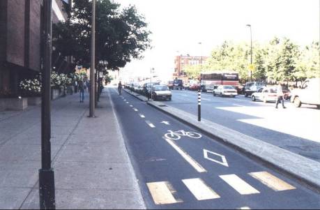
Will Richmond ever do this:
Bike Lanes

Photo: Separated Bike Lanes

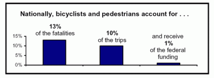
Ever since my Tuesday post about how much I hate cars, I’ve been intrigued by this idea of complete streets that I discovered while researching for that post. The basic idea is that streets should be built for cars, pedestrians, bicycles, and transit. Revolutionary, eh? I’m pretty tired of being run off the road while biking around here- I’ve had so many close calls it’s scary: Car doors opening, SUVs that give you no room, cars turning in front of me- one time on East Main St. an oncoming car turned left and came within inches, literally, of hitting me. Every person on the street stopped and stared.

cts_fatalitieschart_04_d.gif

So far 22 cities have adopted a resolution requiring all new roads to be “complete” and for retrofitting roads when they’re repaved. Several states have adopted similar regulations, although at the state-wide level they seem to have less force, for example several statutes “suggest” that bicycle and pedestrian uses be considered when designing roads. Here’s a list of cities with “complete streets” laws on the books:

California:
Bay Area Metropolitan Planning Organization
Sacrament Co. (including all cities)
San Diego City
San Francisco
Santa Barbara

Colorado:
Colorado Springs
Ft. Collins
Boulder

Florida :
West Palm Beach

Illinois:
Chicago
DuPage Co.

Iowa:
City of Cascade
Iowa City

Michigan:
City of Jackson

Missouri:
St. Louis
Columbia
St. Jospeh

Ohio:
Columbus
Cleveland

Utah:
Salt Lake City

Washington:
Kirkland

Wisconsin:
Madison

VDOT adopted a policy in 2004 which “promote[s] the inclusion of bicycle and pedestrian accommodations in transportation planning activities at local, regional, and statewide levels.” But from the road construction I’ve seen around here, this policy has no teeth.

So what do you think? Will the Richmond region adopt complete street (or similar) policies? Will we ever get a network of urban bike lanes? Do any of you have experience in the cities mentioned above? Or any experience with decent multi-use road construction?

“Henrico’s traffic planners figure that, as a general rule of thumb, the average residence produces the equivalent of 10 vehicular trips per day.”*

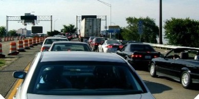
congestion.jpg

Photo: Traffic on I-64.

In the interest of full blogger disclosure, I’ll admit my bias up front: I hate cars – they cause pollution, fatness, and death. I’ve never understood people’s fascination with old cars, luxury cars, those little model cars, any of it. Sure I like the mobility afforded by the automobile, and the ability to get out of town. But any day of the week I’d prefer to bike, walk, or take a train and leave the car at home. One of my proudest moments in using public transportation (I know, it’s a weird thing to be proud of) was when I made my way from my house in Richmond to the airport in DC without a car: I took the 13 bus to Main St. Station, took Amtrak to DC, switched to the metro at Union Station and traveled to L’Enfant Plaza (which necessitated changing lines), and then took the 5a bus to Dulles Airport. It was a beautiful thing. But ridiculously complicated! In Germany, the trains stop inside the airports- here I had to take two metro lines and a bus to get there.

But back to the point at hand. 10 trips a day! Where is everyone going? Let’s see if I can’t figure this out:

Work: 2 trips (1 there, 1 home)
2 people working?: 4 trips

Grocery shopping: 2 trips (but presumably not every day?!?)
Take the kids to school: 4 trips (2 trips to pick them up, 2 to take them home)
Kid’s soccer/ballet/piano lessons: 2 trips per child
Post Office, Drug Store, or other random errands: 2 trips (although, is it 3 trips if you go to the grocery store(1), then the post office(1), then home(1)? Or is that 2 trips? Good lord, I don’t want to be a traffic planner- talk about dull conversations. I’m boring myself just writing this.)

Well I guess that’s it- a household with 1 person working, 2 kids in school who also participate in extracurricular activities, and one daily trip to the grocery store would generate 10 trips.

But, at the risk of boring my readers even more, the National Household Travel Survey (Read their reports, impress your friends!) shows that Henrico’s number is pretty far above the national average. In 2001, the last year I can find data for, the average household took about 6 trips per day (for the nerdy amongst us, more data can be had here). Does the county have real data (one would hope) indicating they’re above the national average? Does the county board chair know what he’s talking about (again, one would hope)? Do they fudge their numbers to make the case for more roads? At any rate, apparently people who live in Henrico drive – a lot – 10 trips a day, every day.

So, do Henrico-ites drive more than the rest of us? Is the whole Richmond region above average (and I mean that in the worst way)? And most importantly, will this ever change?

One of the depressing aspects of this quote was that it came in the context of discussing the New Urbanist development of Rockett’s Landing- a community that’s designed to be walkable and cut down on car dependence. It would seem the county is not counting on this “new” type of development to actually lessen residents’ impact on traffic patterns.

Well, I guess it’s up to all of us to get out of our damn cars. Start using the bus system (it’s not that bad, really!). Bike, walk, and start asking your local politicians to increase our transportation choices. Move somewhere where you don’t have to drive to get to work or the store. We shouldn’t have to use our cars for everything!

For more, read John Sarvay’s recent Buttermilk & Molasses post on “The U.S. Through a Canadian’s Eyes.” – Incidentally, living in Canada is what changed the way I think about cities. I couldn’t agree more with this Canadian’s assessment of the difference between our two societies.

Also, there’s a great movement around the country to build “complete streets” – that is, streets that are built for multiple uses – bikes, pedestrians, etc. Louisville is the latest of 22 cities to adopt a policy to build all new roads as complete streets- and to retrofit old ones when when they’re repaved.

*According to Henrico county’s chairman of the Board of Supervisor, James Donati, Jr., as quoted in the March 5th City Edition article, “Coming Soon to East Main Street: Traffic Tsunami” by Phil Wilayto.