Pedestrians


I can’t decide which is worse. Crossing the street in Italian cities or here in Richmond.

This video shows exactly what it’s like to cross a street in the two Italian cities I’ve visited, Rome and Naples. For you impatient folks, fast forward to 1:12 (-0.52) for the best example.

Now traffic in Italy is absolutely insane. Scooters zip between cars, dividing lines seem to be mere suggestions, and right-of-way is determined like a game of chicken – whoever’s boldest gets to go. One of my taxi drivers said, “Don’t look” as he pulled out into oncoming traffic. He then shrugged and said “Poetic license.”

However, the chaos pauses- if briefly- when a pedestrian enters a crosswalk, even at an unregulated intersection (i.e. one with no stop light.)

Compare this to Richmond where, even when you have a walk signal at a stop light, turning cars will occasionally unapologetically try to mow you down.

In fact, statistics show that the United States is a more dangerous country for pedestrians than Italy.

United States: 1.63 pedestrians deaths for every 100,000 people.

Italy: 1.3 pedestrian deaths for every 100,000 people.

I think the key difference I noticed is that drivers in Italy expect chaos. They expect pedestrians to walk out in front of them, they expect scooters to sneak between their cars, and they expect other cars to pull out in front of them. Which means they’re far more alert than American drivers, and therefore less likely to run someone over.

More chaos=more safety?

There is, in fact, a school of traffic engineering that is trying to bring this kind of chaos to road design in order to make us safer. According to a 2004 article from Salon.com, European traffic engineers are trying to reintroduce chaos to the streets:

“The busier the streets are, the safer they become. So once you drive people off the street, they become less safe.”…

[E]ducation campaigns from the 1960s onward were based on maintaining a clear separation between the highway and the rest of the public realm. Children were trained to modify their behavior and, under pain of death, to stay out of the street. “But as soon as you emphasize separation of functions, you have a more dangerous environment,” says Hamilton-Baillie. “Because then the driver sees that he or she has priority. And the child who forgets for a moment and chases a ball across the street is a child in the wrong place.”…

“The more you post the evidence of legislative control, such as traffic signs, the less the driver is trying to use his or her own senses,” says Hamilton-Baillie, noting he has a habit of walking randomly across roads — much to his wife’s consternation. “So the less you can advertise the presence of the state in terms of authority, the more effective this approach can be.”

Too radical for the United States, I fear. But in Italy, chaos seems to work pretty well on the streets.

I just found the most amazing resource on the web: Walkscore.com

This absolutely brilliant webpage uses google maps and business listings to rate neighborhoods for their “walkability. ” The score is determined by an algorithm based on:

  • The distance to walkable locations near an address.
  • Calculating a score for each of these locations.
  • Combining these scores into one easy to read Walk Score.

The scale:

  • 90 – 100 = Walkers’ Paradise: Most errands can be accomplished on foot and many people get by without owning a car.
  • 70 – 90 = Very Walkable: It’s possible to get by without owning a car.
  • 50 – 70 = Some Walkable Locations: Some stores and amenities are within walking distance, but many everyday trips still require a bike, public transportation, or car.
  • 25 – 50 = Not Walkable: Only a few destinations are within easy walking range. For most errands, driving or public transportation is a must.
  • 0 – 25 = Driving Only: Virtually no neighborhood destinations within walking range. You can walk from your house to your car!

The house I grew up in, located in suburban West End Henrico, scores an abysmal 23. My current address thankfully scores a 74- I’ve chosen where I live because I want to run errands without a car!

I can’t find a Richmond address that scores in the 90’s- are there any? The scores of some popular Richmond neighborhoods, listed in descending order of walkability:

Carytown (address I used: 3200 Parkwood): 85
Jackson Ward (100 W. Marshall): 78
Church Hill (25th & Broad): 72
Fan (1800 Grove): 71
Bellevue (1400 Bellevue Ave): 57
Woodland Heights (300 W. 28th): 35

The flaws in determining scores are readily acknowledged by the creators:

There are a number of factors that contribute to walkability that are not part of our algorithm:

  • Street width and block length: Narrow streets slow down traffic. Short blocks make it easier to navigate the grid.
  • Safety: How much crime is in the neighborhood? How many traffic accidents are there? Are crosswalks well marked and streets well lit?
  • Pedestrian-friendly design: Are there walking paths? Are buildings close to the sidewalk with parking in back? Are sidewalks shaded by trees?
  • Topography: Hills can make walking difficult, especially if you’re carrying groceries.
  • Public transit: Good public transit is important for walkable neighborhoods.
  • Freeways and bodies of water: Freeways can divide neighborhoods. Swimming is harder than walking.
  • Weather: In some places it’s just too hot or cold to walk regularly.

As MarlonBain said, “You should use the Web 3.0 app called going outside and investigating the world for yourself” before deciding whether a neighborhood is walkable!

Also a factor is google’s methods of determining distance. They currently offers only two calculations: “as the crow flies” and driving distance. Walkscore.com has chosen “as the crow flies,” distorting some neighborhoods’ scores.

Distance: We are currently using “as the crow flies” distances rather than walking directions. This means if you live across the lake from a destination, we are assuming you will swim. We are investigating using Google Driving Directions to calculate our distances. Hopefully, Google will add Walking Directions in the future!

And also, google’s business listings are not complete- Bellevue, for example, scores lower than it should as Stir Crazy doesn’t show up, making the closest coffee shop 2 miles away.

Sometimes google’s categories are just plain bizarre: the Richmond Braves are listed as a park, while Bryan Park is not! Convenience stores are tagged as grocery stores.

Nevertheless, this is a great resource that will hopefully have the kinks worked out soon.

The TD ran a story today on Chinese students who are spending a month at VCU. The students are all keeping blogs, which are a rich mine for discovering others’ impressions of our city.

VCU has links to all their blogs, but as far as I can tell, there’s no aggregator- which means you have to look through each of them individually. Quite a task as there’s over 50 of them. I used google’s advanced search features to look for things of interest for my blog.

One theme I found repeated by many was shock at our auto-dependency and its effect on our city- a viewpoint I wholeheartedly share. Here’s some excerpts:

America is regarded as a country on wheels. This is a proper statement to describe this country . I have seen various kinds of automobiles parking of driving around the campus during these two days. And there is little people walking on the street even in the day . The whole town appears a little desolate. This is my first deep impression about the traffic condition around VCU campus. My second deep impression is that though there are various cars on road, the drivers almost do not ring the horn—at least I do not hear a ring. It is impossible in China. Maybe this phenomenon is just the symbol of high civilization of USA. And in my opinion , Chinese drivers should learn from America drivers.
Via blog for luy5

Sadly, the VCU area probably has the most pedestrian activity in town.

On our lack of pedestrians and nightlife:

if Shanghai is a sleepless city,Richmond is a sleep city

Richmond in night looks like a different city. full of cars but no person on the street. Its strange to me becoz its totally different from Shanghai. Shanghai is a sleepless city, the activities of night are varous, compare with Shanghai, Richmond is a quiet city, I heard that the population of Richmond is 80 thousand, its not a small figure, so i wondering, where do the risidents go at night in Richmond?? Stay at home, watching TV?
Via blog for zhuangy

Wow, the population figure’s off by about 110,000 and he’s still shocked at our lack of nightlife!

An incredibly insightful commentary on our auto-dependency:

However, not all the things American are good. There are still something I find impressively unbearable. For example, I find the Americans are lavish. They do not know how to save. They do not know how to save the resources and natural energy. Instead, they are pretty good at saving the energy of themselves. Along the American streets, you can never find a single bicycle. Even if you see a bicycle, it is definitely put on the top of the car. People are inclined to drive everywhere. They do not walk or ride. I think it is part of the reason that why most of them are overweight.
Via blog for liz4

And she’s not the only one making the obesity-driving connection:

It’s our free day today. I decided to go to the Carytown again. I have no car and I don’t want to bother those interns. Thus, I have to walk there, on foot! To my surprise, Carytown’s out of the map, maybe ten blocks away for the GRC [Gladding Residence Center- A VCU dorm]. You can seldom see people walking on the street. Almost all of them drive. Finally I got to the Carytown and I found it was not very far. It’s only about 30 minutes walk. I suddenly thought up with a cause why Americans are fat. Perhaps because they drive too much, sit too long. On one hand, they complain about the soaring gas price, on the other hand, they are so dependent to driving. Instead, if they walk to some places. They will both get jogging exercises and save the gas money. It’s really a bargain!
Blog for Zhang Yi

Try telling some Richmonders “it’s only a 30 minute walk” and see what happens!

Despite the critiques of American culture I’ve highlighted here to advance my own purposes- without exception the Chinese students have positively glowing things to say about Richmond and the US.

On what’s good about Richmond:

At the same time, the wonderful scenery of Richmond is really overwhelming.I love the small bars and restaurants along the fancy streets. I was attracted by the rockiness and wildness of James River. And I was deeply in love with the monuments for the soldiers and sailors who died in the civil war. The most terrific part was the visit to the Virginia Capitol. The house was marvelous and the historic presidents’ stories could not be more significant.
Via blog for liz4

And then there’s the just plain fun of discovering cultural differences, such as impressions of our T-shirt slogans:

Yesterday afternoon we went to Carey Town, which was a place full of shops and stores. Maybe because that China has lots of such shops, I didn’t find it much interesting and attractive. I wanted to buy a T-shirt for my cousin, which were very typical American, but I didn’t find any suitable for him. Some of them seemed too aggresive or radical, maybe. For example, one had a line like “I love your girlfriend” sort of things. If my cousin wears something like that and walks on the road in China, everybody else will probably freak out.
Via blog for wuj4

Thanks to all the Chinese students for visiting our city and sharing your impressions with us!


VDOT and the Virginia Capital Trail Foundation are building a 55 mile bike & pedestrian trail linking Williamsburg, Jamestown, and Richmond – the current and former capitals of Virginia.

Parts of the trail are already open in James City County: see photos here.

Current discussions are ongoing regarding the exact route and location of the trail in the Varina area of Henrico Co. This is where things get depressing.

First, there’s the timing. According to the planners, the trail won’t open until 2012. And we all know how accurate construction projections are, so it very possibly could take even longer. Call me impatient, but I was hoping for a quicker completion.

Second, there’s Henrico Co. government who seem to be trying their best to design this project to suit their car-dependant needs. Today’s TD outlines the desire of Henrico Board of Supervisors Chairman James B. Donati Jr.:

…he hopes to influence the trail’s design.

He believes the trail should be built as an extended shoulder of Route 5, instead of a swath of pavement separated by grass and landscaping.

He contends a wide shoulder would make Route 5 safer, because it would accommodate cyclists and slow-moving farm equipment, plus give room for delivery trucks to stop without impeding traffic on the 55-mph road.

Now contrast this with the stated purpose of the trail, as outlined by the Virginia Capital Trail Foundation- which is collecting private money to supplement inadequate government funds for this project:

The Trail is designed for non-motorized use and welcomes hikers, cyclists, walkers, joggers, skaters, birders, families taking short day trips and chaperoned school children on eco-field trips.

The Trail will provide safe recreational access to the region and link popular tourism destinations. It will offer cyclists a safe transportation alternative to Route 5…

So somehow in the twisted world of Donati and possibly others in Henrico gov’t, the trail should be open to use by “slow-moving farm equipment” and parked delivery trucks- which is completely incompatible not only with the trail’s purpose, but also with bicycle and pedestrian safety, and presumably the premise under which funds for the trail were secured.

And it’s galling that he argues that this would make a “safer” Route 5. Safer for whom? The only people who benefit from Donati’s vision are those in cars- not those who’re using the Capital Trail.

Can you see groups of school children on eco-field trips dodging tractors and walking around UPS vans while 55 mph+ SUVs and tractor trailers zoom by only inches away? Brilliant idea!

And of course, the newspaper, who we assume was present when Donati made these comments, did not bother to question him on the contradiction between his vision and the trail’s purpose (or if they did, they neglected to report it.) Because, really, who in Richmond doesn’t want to make the world safer for cars, even if it’s at the expense of pedestrians, cyclists, and little school children?

So as promised, albeit after a long delay, I’m starting what I hope will be a regular feature of this blog: highlighting good ideas for cities.

To kick things off, I’m taking the suggestion of a reader who brought to my attention an idea from Columbus, OH.

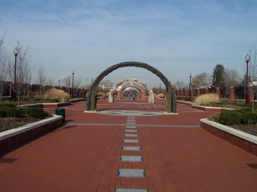
Ohio DOT wanted to widen I-670, so in one location, the decision was made to hide the highway by building retail shops along the bridge. Here’s a picture:

And a view from street level, where you really can’t tell it’s a highway overpass at all:

This is a great idea, because instead of allowing the highway to divide neighborhoods and destroy them for the sake of the automobile, this development allows neighborhoods to remain pedestrian friendly and maintains a connection between both sides of the highway (at least in this one space).

According to the Columbus City Council webpage, they’re considering highway “caps,” as they’re known, all over the city. Check out these links, which show pictures of 4 different highway overpasses and proposals to cap them with buildings or parks (be sure to click on the “next” link). It’s really an amazing transformation they’re proposing:

http://assets.columbus.gov/Council/initiative/caps/spring/1.htm
http://assets.columbus.gov/Council/initiative/caps/broad/1.htm
http://assets.columbus.gov/Council/initiative/caps/third/1.htm
http://assets.columbus.gov/Council/initiative/caps/high/1.htm

Of course, Columbus is not the only city to hide its highways- Boston’s Big Dig is the most infamous of all attempts to reclaim urban space from the ravages of the interstate highway system. But other cities are getting in the game as well:

Dallas, TX wants to connect it’s arts district and Uptown neighborhoods with a 3 block-long park:

Trenton, NJ created a 6.5 acre park over US 29 which sparked reinvestment in neighboring areas. A view from “street level”:

Other cities with caps include Seattle (I-5), San Diego, Duluth (I-35), and Phoenix (I-10).

Of course, Richmond has 2 caps already, the RMA parking garage and Kanawha Plaza. While over a highway is one of the best places to put parking, as it uses otherwise wasted urban space, Kanawha Plaza is closer in concept to these other developments because it serves to connect both sides of the Downtown Expressway.

Kanawha, however, is much smaller in scale than these newer caps. And it’s also flanked by busy streets on both sides, which diminishes its ability to actually connect the two sides of the expressway as it’s not pleasant to walk there.

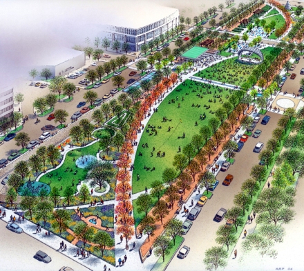
So Good Idea #1: hide the highways by capping them and reconnecting divided neighborhoods. Where could this work in Richmond? Perhaps in Oregon Hill? Maybe a retail cap along S. Meadow St. near the near the new lofts? What do you think?

When I used to live near the expressway in Carytown I dreamed of a green-space cap that would cover the entire expressway as a bike and walking path to downtown as well as heal the ugly scar in the neighborhood and deaden the incessant noise. Now that I see so many other cities getting into this game, perhaps it wasn’t such a far-fetched dream after all…

ddexpressway2.JPG

And please, send me some good ideas you’ve seen in other cities or have dreamed up yourself.   Let’s think big for Richmond. Send ideas here: ambivalentrichmonder [at] yahoo.com

Will Richmond ever do this:
Bike Lanes

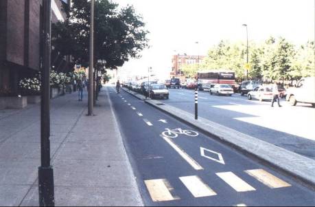
Photo: Separated Bike Lanes

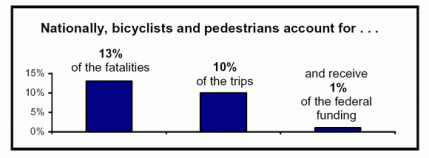
Ever since my Tuesday post about how much I hate cars, I’ve been intrigued by this idea of complete streets that I discovered while researching for that post. The basic idea is that streets should be built for cars, pedestrians, bicycles, and transit. Revolutionary, eh? I’m pretty tired of being run off the road while biking around here- I’ve had so many close calls it’s scary: Car doors opening, SUVs that give you no room, cars turning in front of me- one time on East Main St. an oncoming car turned left and came within inches, literally, of hitting me. Every person on the street stopped and stared.

cts_fatalitieschart_04_d.gif

So far 22 cities have adopted a resolution requiring all new roads to be “complete” and for retrofitting roads when they’re repaved. Several states have adopted similar regulations, although at the state-wide level they seem to have less force, for example several statutes “suggest” that bicycle and pedestrian uses be considered when designing roads. Here’s a list of cities with “complete streets” laws on the books:

California:
Bay Area Metropolitan Planning Organization
Sacrament Co. (including all cities)
San Diego City
San Francisco
Santa Barbara

Colorado:
Colorado Springs
Ft. Collins
Boulder

Florida :
West Palm Beach

Illinois:
Chicago
DuPage Co.

Iowa:
City of Cascade
Iowa City

Michigan:
City of Jackson

Missouri:
St. Louis
Columbia
St. Jospeh

Ohio:
Columbus
Cleveland

Utah:
Salt Lake City

Washington:
Kirkland

Wisconsin:
Madison

VDOT adopted a policy in 2004 which “promote[s] the inclusion of bicycle and pedestrian accommodations in transportation planning activities at local, regional, and statewide levels.” But from the road construction I’ve seen around here, this policy has no teeth.

So what do you think? Will the Richmond region adopt complete street (or similar) policies? Will we ever get a network of urban bike lanes? Do any of you have experience in the cities mentioned above? Or any experience with decent multi-use road construction?